Drone-powered aerial mapping and surveying deliver a rapid, precise, and budget-friendly solution for collecting data over expansive areas. Whether you’re looking for topographic maps, detailed 3D terrain models, or accurate volumetric measurements, our advanced drone technology provides scalable, high-resolution results tailored to your needs. From construction zones to agricultural fields, we capture critical site data with speed and accuracy—streamlining workflows and reducing reliance on slower, costlier traditional surveying methods.
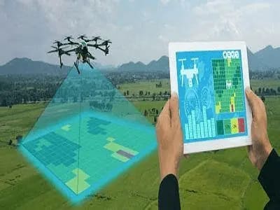
Aerial mapping and surveying involve the use of drones equipped with high-resolution cameras, LiDAR sensors, or multispectral imaging systems to capture detailed images and data. These drones can survey large areas efficiently, producing accurate maps, 3D models, and geo-referenced images.
The data collected can be used in various sectors, including construction, agriculture, real estate, and environmental monitoring.
Drones create detailed 2D and 3D maps, providing accurate terrain data for planning and construction projects.
Advanced sensors capture precise elevation data, offering more detailed insights than traditional ground surveys.
Drone mapping technology provides centimetre-level accuracy, ensuring you get reliable and precise data for your project.
Drones can cover large areas in a fraction of the time it takes traditional surveying teams, delivering results faster.
Reduced labour and equipment costs make aerial mapping an affordable option for large-scale surveys.
Drones can survey hazardous or difficult-to-reach areas, reducing the need for personnel to work in potentially dangerous conditions.

We’re committed to delivering exceptional quality and uncompromising safety in every drone operation we undertake. By leveraging top-tier technology—specifically DJI drones—we ensure optimal performance, reliability, and precision. As a global leader in drone innovation, DJI offers advanced capabilities including high-resolution imaging, powerful sensors, and pinpoint flight control, making it the ideal choice for professional-grade aerial work.
Every mission—whether it’s surveying, site monitoring, or data collection—is executed with accuracy and efficiency at the forefront.
In addition to using industry-leading equipment, we are fully certified by the Civil Aviation Safety Authority (CASA). This certification guarantees that all our drone operations strictly adhere to Australian aviation safety regulations. Our team is trained to operate safely and compliantly, even in complex or restricted environments, ensuring responsible execution across all projects.
By combining cutting-edge drone technology with CASA-accredited expertise, we provide secure, professional, and high-precision services across diverse industries. Our clients benefit not only from the quality of our deliverables but also from the assurance that every flight meets the highest standards of safety and compliance
The data collected can be used in various sectors, including construction, agriculture, real estate, and environmental monitoring.